Published:
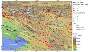
Tectonic map of the study area in Slovenia
Picture: Manuel DiercksIn a new paper we investigate the tectonic geomorphology of Western Slovenia. This region is seismically active due to the northward motion of the Adriatic Plate. In previous studiesExternal link we have already worked on the paleoseismological record of the largest faults. Here we applied standard techniques that are commonly used to evaluate a region's tectonic activity on a large scale. These are using the topography and properties of the drainage pattern to infer if a region is deforming or not. Surprisingly, some of these established methods failed to identify faults that we know are active, while several inactive faults gave false positive results. We then investigated single fault traces in more detail, but still found that several of the applied methods did not work satisfactorily. Finally, we focussed on a single karst polje located on the Idrija Fault using data with very high resolution, but with limited insights.
We use these examples to explain why the standard techniques often fail. In our case, it's mainly karst processes that control landscape evolution and that disturb the drainage pattern. Lithological changes also lead to signals that can be confused with those of active tectonics. Since our region of interest is deforming very slowly, tectonic deformation is often outpaced by other landscape-forming processes. We argue that many studies do not take these effects properly into account, especially if they are not accompanied by field work.
Reference:
Diercks, M.-L., Grützner, C., Welte, J. & Ustaszewski, K. (2023). Challenges and Limits of Remote Sensing of Active Tectonics in the Slowly Deforming Karst Landscape of W Slovenia and NE Italy. Geomorphology. https://doi.org/10.1016/j.geomorph.2023.108894External link
