Published:
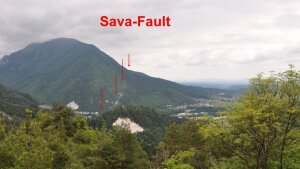
The Sava Fault Tržič, view to the East.
Image: Christoph GrütznerThe Sava Fault is one of the most active faults in Slovenia, but has most likely not triggered an earthquake with destructive consequences in the last few centuries. What is a blessing for the population, however, is problematic for researchers: earthquakes allow us to understand how faults work. In a new article, Jamšek Rupnik et al. present new data on the Sava Fault and our group was involved in the work. Remote sensing data were used to evaluate information on the activity of the fault “stored” in the landscape, e.g. in deformed fans. Geophysical measurements and geological mapping were used to precisely describe the geometry of the fault. Preliminary dating suggests that the Sava Fault has had an average slip rate of 1.8 ± 0.4 mm per year over the last 27,000 years. The paper was published in Remote Sensing and is open access:
Jamšek Rupnik, P., Atanackov, J., Horn, B., Mušič, B., Zajc, M., Grützner, C., Ustaszewski, K., Tsukamoto, S., Novak, M., Milanič, B., Markelj, A., Ivančič, K., Novak, A., Jež, J., Žebre, M., Bavec, M., & Vrabec, M. (2024). Revealing Subtle Active Tectonic Deformation: Integrating Lidar, Photogrammetry, Field Mapping and Geophysical Surveys to Assess the Late Quaternary Activity of the Sava Fault (Southern Alps, Slovenia). Remote Sensing, 16, https://doi.org/10.3390/rs16091490External link.
